The 24 July 2007 GEM LAM Simulation of the Dryline
An Informal Investigation into Dryline Morphology Over the Alberta Foothills
Neil Taylor
Hydrometeorology and Arctic Lab (HAL)
23 August 2007
Introduction
On Tuesday 24 July 2007 a well-defined QS dryline was observed along the Alberta foothills and played a role in the initiation of at least one
severe storm. This storm became a mini supercell and tracked eastwards just N of Calgary producing numerous reports of severe hail and wind
damage. At one point during the storms lifetime a tornado warning was issued by the PASPC and the Alberta
Emergency Public Warning System activated. The discussion here is less about the storm itself than it is a review of the simulation of the
dryline by the 2.5 km configuration of the GEM Limited Area Model (LAM). The discussion here is very informal (and incomplete) but is an example of how the LAM simulates the the dryline and some interesting features associated with the simulation of this boundary. A central question prompting this investigation is whether the dryline observed in Alberta (or simulated by the GEM LAM in this case) exhibits features that are consistent with those observed with drylines elsewhere. Further study of LAM simulations of the dryline in AB may aid in experimental design considerations for UNSTABLE (the UNderstanding Severe Thunderstorms and Alberta Boundary Layers Experiment) as it relates to sampling this feature. The domain shown in the LAM fields is centered on the domain for the UNSTABLE project and was kindly produced by Neil McLennan (PYR)..thanks Neil! The graphics generated from MAX were generated with the help of Garry Toth.
Background on the Dryline on the Canadian Prairies
The dryline is a convergence boundary that has long been recognized on the US plains as a focus for the development of thunderstorms. The near-dryline environment is characterized by a hot, dry, and deeply-mixed atmospheric boundary layer (ABL) on the dry side of the boundary and a cooler, moist, shallower and capped ABL on the moist side. The capping lid over the moist air results in a classic loaded gun environment often associated with severe thunderstorms. Convergence and lift near the moisture gradient at low levels provides a mechanism for parcels in the moist air to reach their level of free convection thus breaking the cap and promoting the development of deep convection.
The dryline on the Canadian prairies has garnered increasing attention over the last number of years and is a central focus of the UNSTABLE project under development (see this
link to the external UNSTABLE site hosted by the University of Manitoba for more information). The dryline on the Canadian Prairies tends to form along the Alberta foothills under the influence of southwesterly flow over the mountains. Similar to the development of a Chinook, air subsiding in the lee of the mountains dries and warms as it is mixed towards the surface (though this process may occur in combination with gap winds in some locations). Under preferred axes of stronger winds over the mountains (e.g., at 700mb) the dryline has been seen to bulge to the east as increased momentum at higher levels is mixed to the surface.
The primary importance of the dryline is that it acts as a focus for convective initiation (CI) as the boundary is associated with low-level convergence. Moreover, the near-dryline environment is conducive to the development of severe thunderstorms as warm air over-running the moist ABL to the east of the boundary creates a capped environment allowing moisture to pool under the cap and sometimes result in rapidly developing storms. Kinematically, in the moist air a weak-upslope component to the flow is typically observed so that, when combined with strong southwesterly flow aloft, the pre-storm environment is characterized by sufficient deep-layer vertical shear for the development of supercells.
For those interested, the PowerPoint presentation below gives more detail on the dryline in AB as well as some preliminary work on dryline-associated severe weather events. Also included is a link to a paper documenting the role of the dryline in a severe weather outbreak in Alberta on 29 July 1993 and the 2006 M.Sc. Thesis by Leslie Hill at the University of Alberta. Some other suggested reading on the dryline is given at the bottom of this page.
Genesis and Morphology of the Alberta Dryline- (click to advance slides) portions of this presentation were presented at the 35th and 38th Annual CMOS Congress and this presentation is currently offered to the MOIP program as part of their convective simulator.
Operational Aspects of the Alberta Severe Weather Outbreak of 29 July 1993- Published in National Weather Digest (December 2000), 24:4, 11-23.
Drylines Observed in Alberta During A-GAME- University of Alberta M.Sc. Thesis by Lesley Hill (2006).
24 July 2007 - General (Upper-Air) Synoptic Situation
Since the focus of this discussion is on the model simulation of the dryline, the analysis discussion included here is limited at this time to upper-air charts and is only intended to provide a cursory understanding of the synoptic environment. It is fully acknowledged that this is not a sufficient discussion for complete understanding of the pre-storm environment.
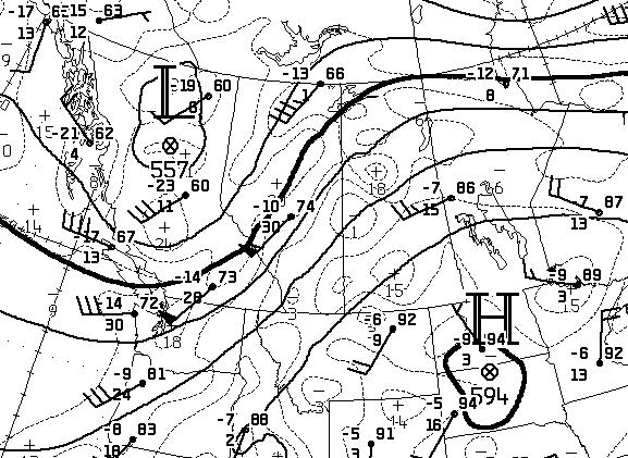
12Z 24 July 2007 - 500mb Analysis (click on image to enlarge)

The 500mb analysis map shows a classic upper-air pattern for an AB severe weather day with strong southwesterly flow aloft and a cold trough over BC. On this particular day there was some concern for the potential of severe weather in SK as well. Even though it was warmer aloft there the higher dewpoints and deeper moisture resulted in higher CAPE values than over AB. The 60kts on the WSE sounding suggest a strong deep-shear environment over most of AB, even without strong upslope winds at low levels.
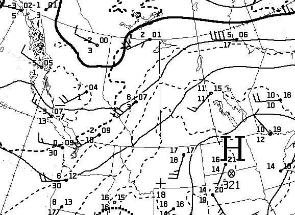
12Z 24 July 2007 - 700mb Analysis (click on image to enlarge)

At 700mb the thermal pattern shows the main thermal ridge axis runs near the AB/SK border and wraps back into northern AB, this suggests the main mid-level cap would be a problem mainly in SK with some mid-level cooling over AB. More interesting is the SW flow over the mountains of 20 or more kts. This type of flow has been identified as important for dryline genesis in response to subsidence in the lee of the mountains. This is also important for maintaining some weak capping along the dryline boundary (on the moist side) to allow moisture to pool for some time prior to convective initiation (CI).
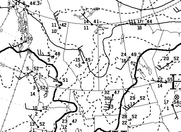
12Z 24 July 2007 - 850mb Analysis (click on image to enlarge)

At 850mb there are hints of a low near the YLL area along the AB/SK border and a cold front oriented from NE to SW over SE AB. The warm sector is over southern SK with the KGGW sounding showing a 30kt southerly LLJ. Southern SK was favourable both thermodynamically and kinematically for the occurence of severe weather...the question there was whether the cap would break or not. In AB CI was nearly certain along the dryline but there was some question as to whether there was sufficient buoyancy to support organized storms, if storms did develop they were expected to take on supercellular characteristics given the strongly sheared environment. The discussion that was posted on the RSD on this day is available
here for interest.
Selected Full-Resolution GEM Fields (developed as part of the RSD initiative)
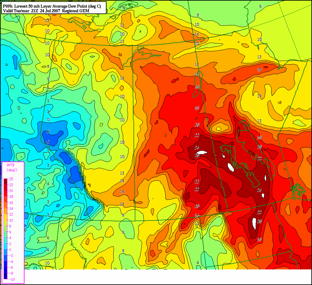
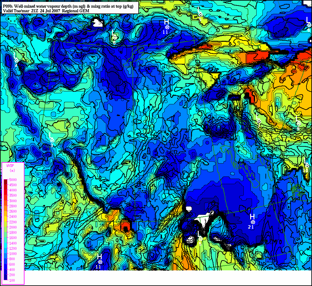
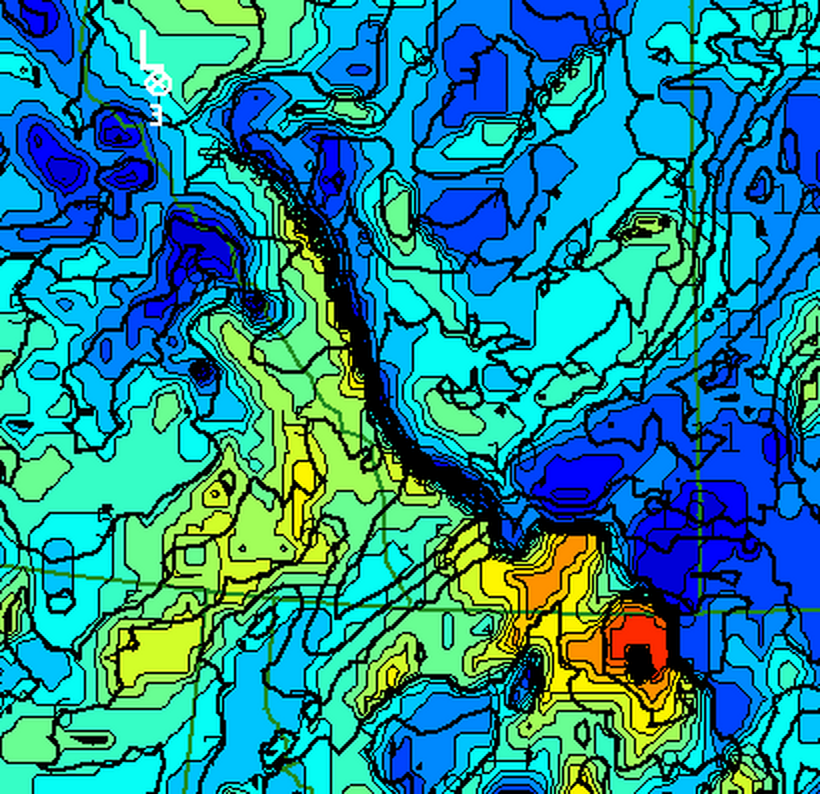
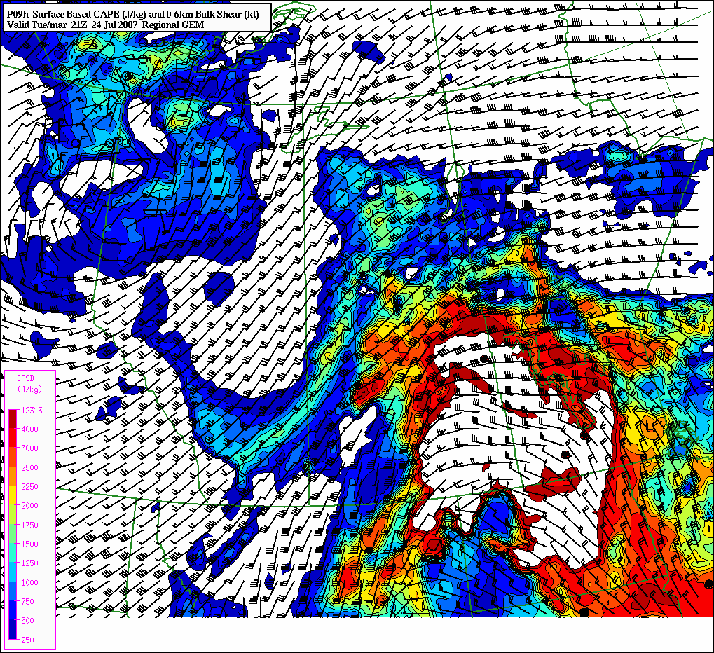
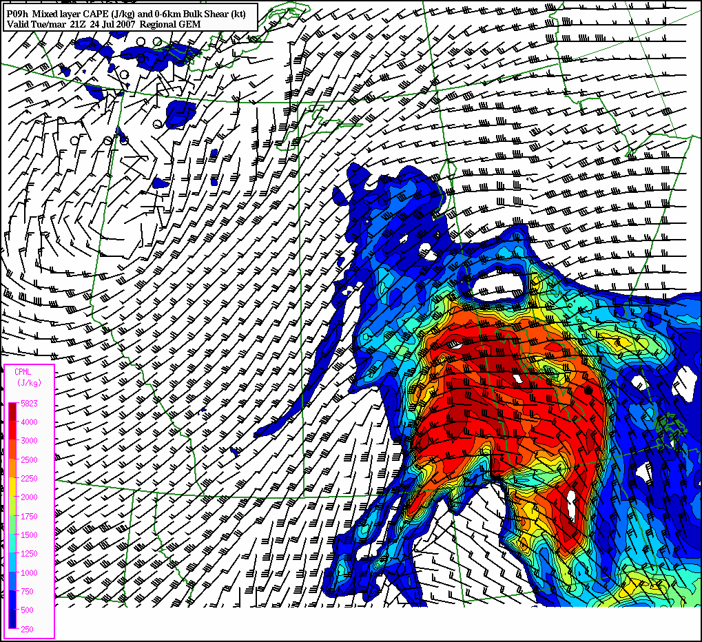
A few images used on the RSD during the summer of 2007 illustrate some characteristics of the forecast environment on the 24th (all images here are from the 12Z run of GEM 15). The forecast 50mb mean dewpoint at 21Z (Image 1) shows the highest dewpoints over the eastern praires with a tongue of moisture trailing back into southern AB. This field highlights the forecast location of the dryline well with forecast negative dewpoints on the dry side directly adjacent to dewpoints in the 10-12 degree range on the moist side. Another field being tested on the RSD in 2007 was forecast mixed moisture depth and mixing ratio. It has been shown elsewhere that depth of moisture available in the prestorm environment has an influence on the liklihood of CI and updraft intensity. This field at 21Z (Image 2) shows the discontinuity in moisture depth typical of the near dryline environment. On the dry side of the boundary forecast mixed moisture depths are in the 2000m range but with mixing ratios of only 4-5 g/kg. On the moist side of the boundary the ABL is typically shallower, this field shows mixed moisture depths of only ~800m adjacent to the dryline boundary. Areas further in the moist air tend to be mixed a little deeper and this is reflected by this field with mixed moisture depths increasing to ~1200m to the east of the dryline. An enlarged view of this field is shown in Image 3. Images 4 and 5 show the GEM 15 forecast surface-based (SB) and 50mb mean-layer (ML) CAPE, respectively. Both of these images have 0-6 km bulk shear vectors superimposed over CAPE with black wind barbs. On this day model MLCAPE was small over the foothills (~250 J/kg) while SBCAPE (biased by higher mixing ratios in the lowest layer of the model) showed CAPE values near 1000 J/kg. Much of southern SK was characterized by high CAPE and shear in excess of 30 kt.
| Image 1 (Mean Td) |
Image 2 (Mixed WV Depth) |
Image 3 (WV Depth Zoom) |
Image 4 (SBCAPE & Shear) |
Image 5 (MLCAPE & Shear) |
 |
 |

|  |
 |
Mesoanalyses and Storm Track
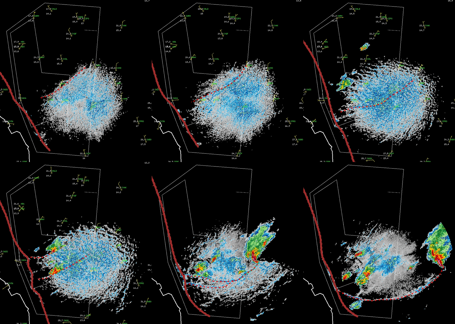
At 2030Z the storm of interest was initiated in close proximity to a dryline along the AB foothills. This storm evolved into a mini supercell with impressive radar structure and resulted in multiple reports of severe hail. Below is a loop (click on the image to open the full sized window) of hourly mesoanalyses from 18-02Z showing the position of the dryline, SFC observations, 0.5 degree PPI corrected LogZ reflectivity, and positions of storm outflow boundaries.

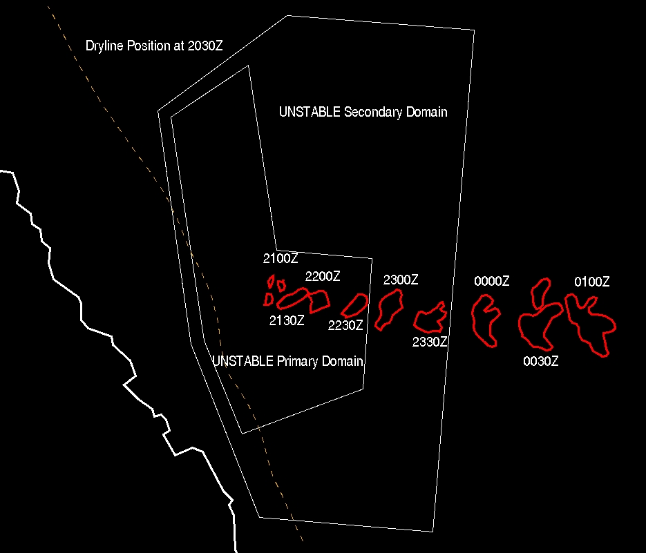
Illustrated below (click on the image for the full-sized window) are the position of the dryline at 2030Z (the time that the first radar echoes were observed) as a dashed line. The white polygons are the primary and secondary UNSTABLE domains. The red contours are 30 minute outlines of the 40 dBZ echoes (approximate) showing a clear supercellular structure by 0000Z.

GEM Simulation of the Dryline
The images and discussion here are not meant to verify the location, intensity, or timing of the simulated dryline against observations. Rather, the intention is to show an example of the dryline as it is simulated by the GEM LAM in the context of conceptual models for the near-dryline environment on the US Plains and in Alberta. The dryline is forecast by the GEM in both 15 km and 2.5 km configurations fairly regularly in Alberta and there is nothing particularly special about this one other than it was selected for closer study.
Time Evolution of Selected Fields
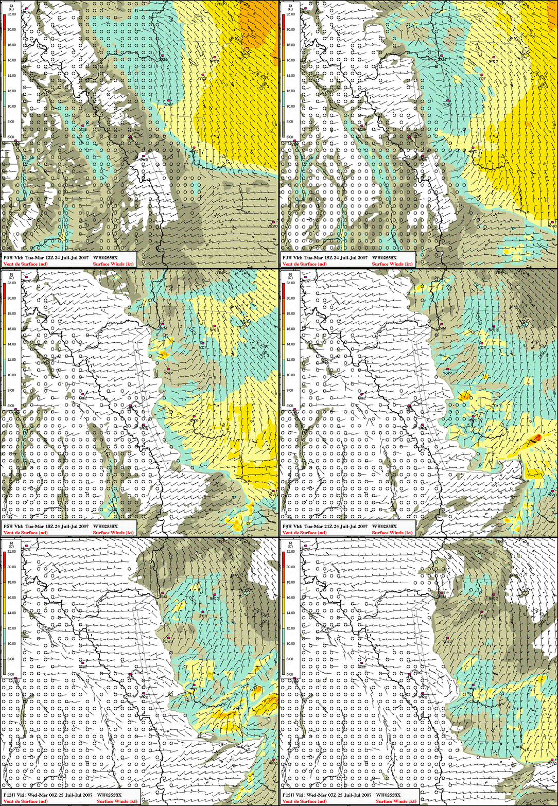
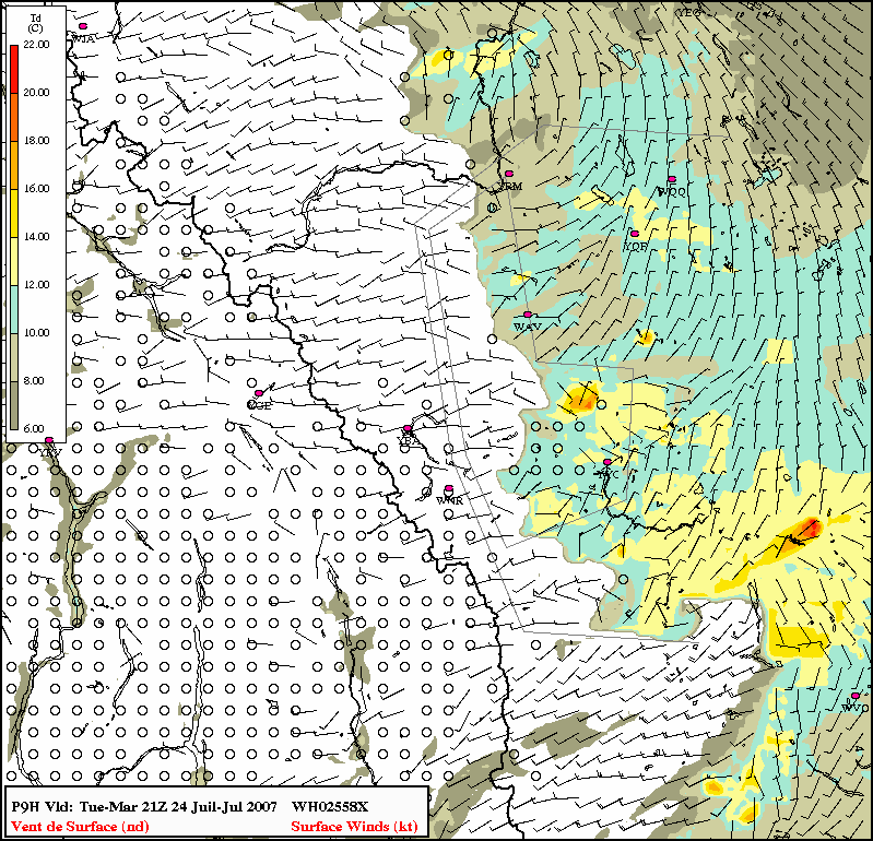
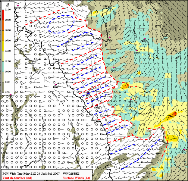
The dryline is characterized by a strong moisture gradient at the surface and is usually (though not necessarily) co-located with a convergence line evident in the SFC wind field. Included below are animations of the forecast SFC dewpoint and windfield, 0.985 eta-level winds and vertical motion, and 700 mb winds and vertical motion (click the thumbnail to activate the animation in another window). The animation of the SFC dewpoint and wind fields shows the SFC dewpoint gradient tightening up during the period 12-16Z along the western border of the UNSTABLE domain (light gray lines) accompanied by a well-defined convergence line in the SFC wind field. Though SFC dewpoints are not contoured below 6 degrees C in this image, approximately north-south through the UNSTABLE domain there is a strong gradient with 10-12 deg C dewpoints on the E side of the boundary and Td < 6 deg C on the west side. The LAM simulation shows a high degree of along-dryline variability, a feature that has been observed with drylines on the US plains but never in Canada. There are hints at the presence of misocyclones on the dryline itself, these have also been observed in the US but this is the first time they have been discussed in Alberta (we'll return to these later). The dryline is seen to advect eastward through the UNSTABLE domain until ~ 20Z when it stalls. Note however that along the southern boundary of the UNSTABLE domain the dryline is seen to bulge significantly to the east, this bulging is observed in the the SFC observations and radar fine line structure of the boundary near the end of the mesoanalysis animation above. Stronger southwest SFC winds are evident in the dry air behind the bulge resulting from mixing to the SFC of upper-level momentum in the lee of the mountains.
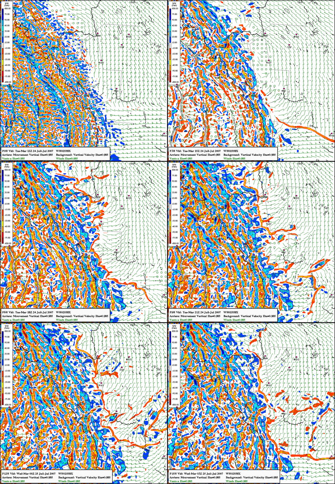
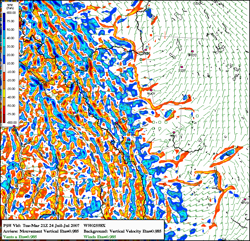
The second animation is of the GEM LAM 0.985 eta-level wind and vertical velocity. The along-dryline variability is evident in the low-level vertical motion field as we do not see a continuous line of low-level ascent along the dryline but rather intermittent segments of lift that can only be resolved by this higher resolution configuration of the GEM. Note that the areas to the west, i.e., on the dry side, of the boundary, are dominated by low-level descent in the generally westerly winds.
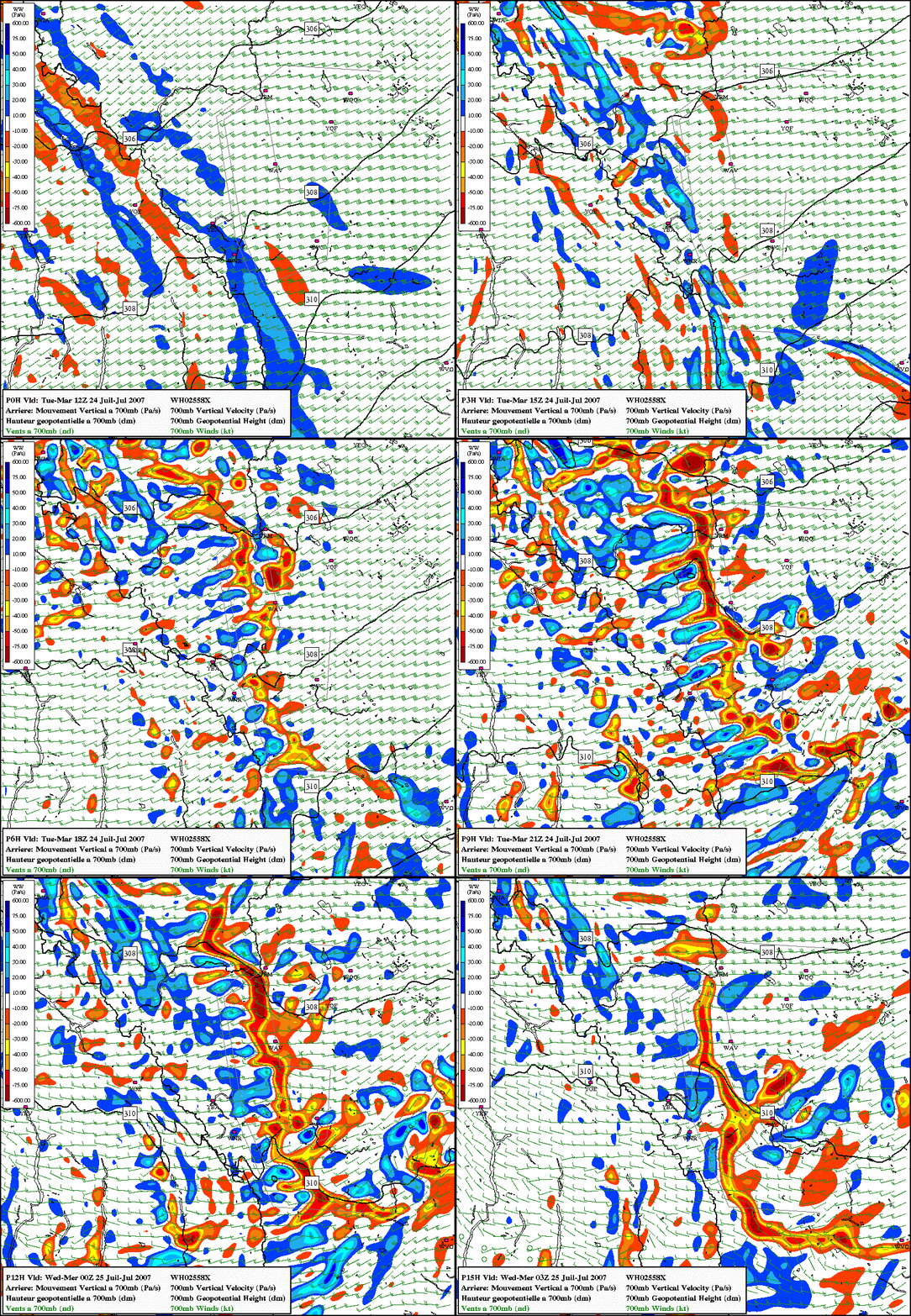
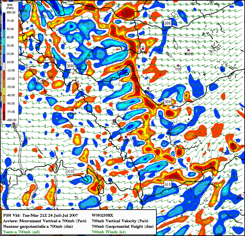
The last animation shows the evolution of the winds and vertical velocity at 700mb (near the height of the mountains). Not surprisingly, the vertical velocity field on the dry side of the dryline is dominated by subsidence. Prior to 18Z the subsident area is reasonable uniform but the field changes significantly after this time. By 21Z the LAM shows axes of enhanced subsidence elongated in the direction of the mid-level flow. In the vicinity of the dryline there are axes of enhanced ascent between the descent regions suggesting the presence of horizontal rolls with axes oriented with the flow both above and throughout the boundary layer (vertical shear on the dry side of the dryline tends to be unidirectional). The dryline boundary itself is associated with fairly strong ascent up to 700mb, even along the bulging portion along the southern edge of the UNSTABLE domain. Behind the bulge in the dry air we see a larger persistent area of subsidence (oriented in the direction of the 700mb flow, i.e., the direction of the bulge) at 700mb reaffirming the notion that the bulging of the dryline is due to subsidence in the dry air and mixing of upper-level momentum to the surface.
| SFC Dewpoint and Wind |
0.985 eta Wind and VV |
700mb Wind and VV |
 |
 |

|
A Closer Look at 21Z (T+9 Hours)
For the purposes of illustration the discussion below focuses on the 21Z time period (T+9 hour GEM LAM forecast). At this time the dryline is well defined in the model simulation (and in observations, recall the severe storm was initiated along the dryline at ~2030Z). Still images at 21Z for the same three fields as animated above are shown below.
| SFC Dewpoint and Wind |
0.985 eta Wind and VV |
700mb Wind and VV |
 |
 |

|
Examination of these snapshots show that the main axis of ascent associated with the dryline is directly above the strongest moisture gradient at the surface. The ascent along the boundary is nearly continuous at 700mb but at the lowest levels is less continuous with preferred regions of strong ascent where there appears to be the strongest convergence and weaker (or almost no) ascent in areas where convergence is weak. Near and to the west of the dryline the 700 mb vertical velocity field shows alternating areas of ascent and descent with axes parallel to the flow. As already noted, this may suggest the presence of longitudinal rolls similar to (though perhaps larger in scale than) horizontal convective rolls. The origin of these rolls is unclear but they would appear to be driven by subsidence as the axes of descent appear stronger and extend further upstream while the ascent areas appear to only be present in close proximity to the dryline. If the axes of 700 mb ascent (dashed red lines) and descent (dashed blue lines) are overlaid on the SFC wind and dewpoint fields (see image below - blue oval in image is a large area of descent) a response can be seen in the SFC winds. Under axes of 700mb ascent the SFC winds show convergence while under areas of descent SFC divergence is present. The areas of convergence and divergence appear weak as the wind pattern is deformed in the predominant southwesterly flow. When compared with the mixing ratio field there appears to be a correlation between ascent (descent) areas and higher (lower) mixing ratio at the SFC. This is similar to findings elsewhere when considering horizontal convective rolls where the updraft branches of the circulation are collocated with higher moisture content and are preferred regions for CI. Could these horizontal rolls contribute to CI along the dryline?

Also of interest is a quick comparison of the SFC (and 0.985 eta) winds and those at 700mb. Note that on the dry side of the dryline the winds at both low levels and up to 700mb have a westerly component. In contrast, the winds on the moist side of the dryline tend to be northeasterly (or at least have an easterly component) with stronger southwesterly flow aloft. The deep-layer vertical shear is thus maximized on the moist side of the dryline.
Eastward advection of the dryline would appear to be mainly in response to the slightly stronger winds on the dry side of the boundary and the strongest convergence lines are in regions where the westerly winds are strongest. This may suggest that the convergence at the boundary is driven mainly by the dry westerly winds as would be expected in a Chinook situation. While this may appear to be a subtle point, it differs significantly from conceptual models for the dryline in the US where the consensus seems to be that the dryline is driven by a frontogenetic circulation due in large part to the thermal discontinuity across the dryline. One of the questions to be explored during UNSTABLE is whether the dryline in AB evolves like its US counterpart or whether the mechanisms responsible for dryline genesis and evolution in AB differ from those on the US Plains.
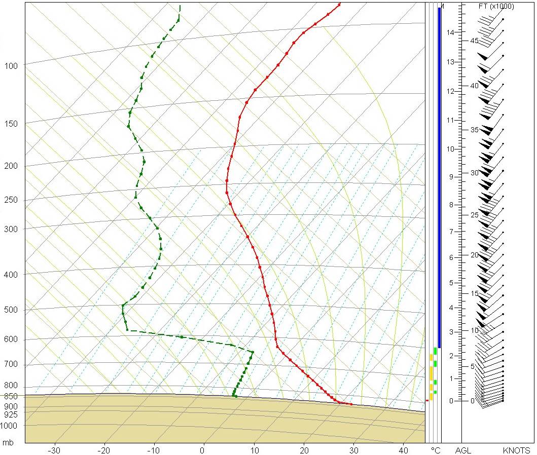
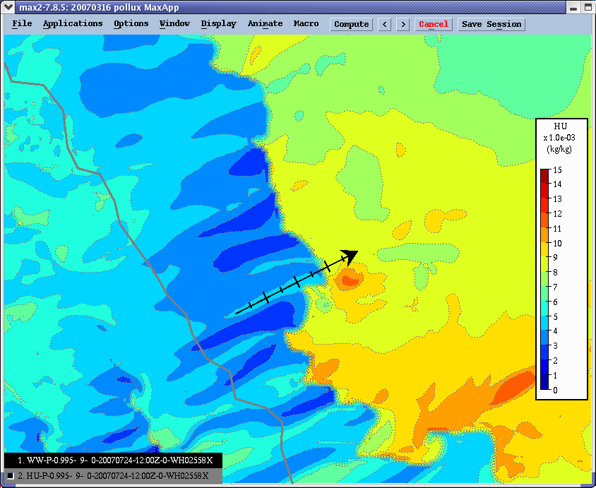
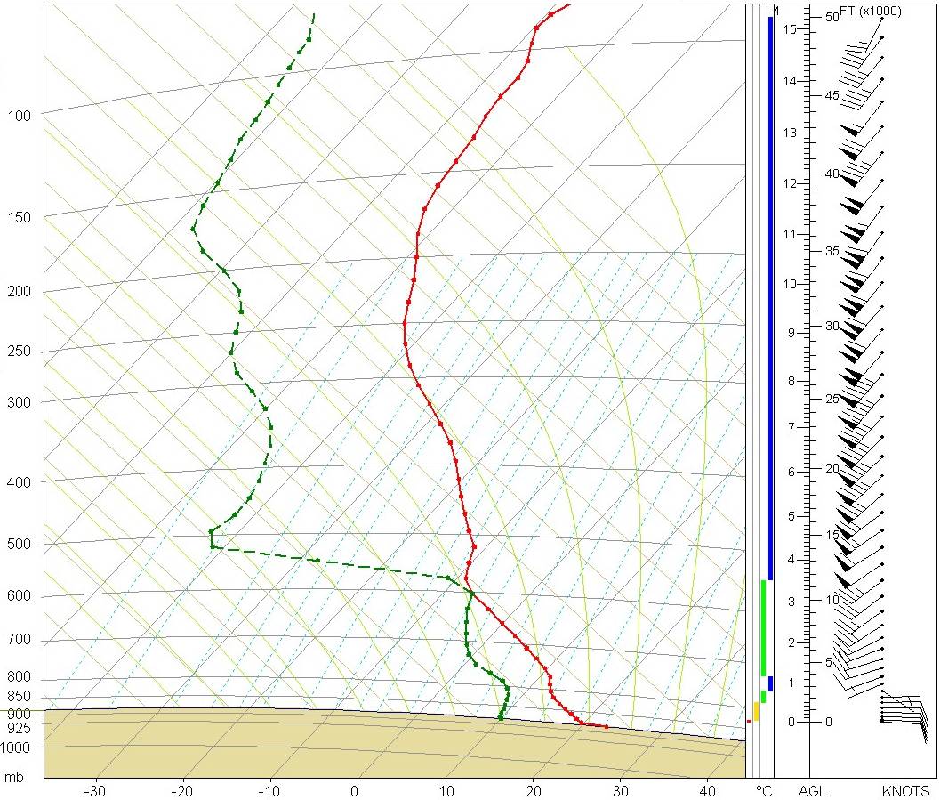
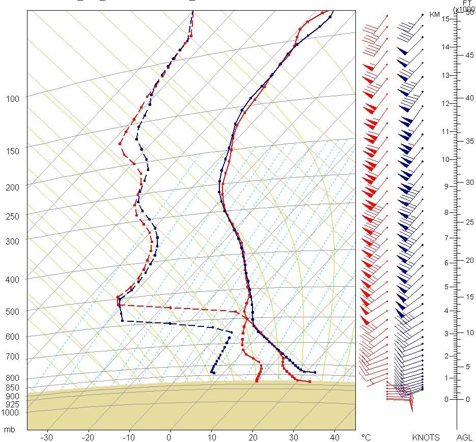
To obtain a clearer picture of how the LAM simulates the dryline requires a closer look at the model output more directly. The three images below (click on images for full-sized window) show a cross section extending from near Banff (YBA) to near Sundre (WAV) and BUFR profiles for YBA (left) and WAV (right) at 21Z. The BUFR profiles are taken from the same LAM run as the center image (i.e., 12Z 24 July 2007 run initialized using 00Z 24 July 2007 GEM REG). The BUFR points are not ideally located to characterize the near-dryline environment but are the closest locations for which profiles were readily available.
| Banff 21Z BUFR Profile |
SFC Mixing Ratio |
Sundre 21Z BUFR Profile |
 |
 |

|
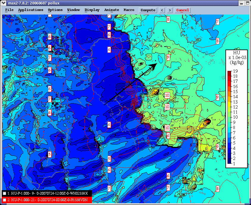
The SFC mixing ratio image is very similar to the SFC image shown earlier but should remove elevation effects from the moisture field as mixing ratio is conserved with height while dewpoint is not. The position and appearance of the dryline is the same and there is a very strong moisture gradient over a very short distance (lack of scale on the images makes estimation of the distances difficult) with a contrast in mixing ratio of ~5 g/kg. The Banff profile (left) shows a well-mixed boundary layer up to 630 mb (2355 m AGL in the model). With the exception of a slightly higher SFC mixing ratio, the LAM mixes the moisture throughout the depth of the ABL with a mixing ratio of 3.5 g/kg. The winds in this profile are uniformly from the southwest with a nearly unidirectional hodograph (not shown). The winds increase in speed to a maximum of 108 kts at 9.7 km. The profile shows the ABL is too dry to support moist convection with no positive CAPE available to a lifted parcel. The WAV profile (right) shows the ABL mixed to only 819 mb or 655 m AGL in the model. At this level there is a slight warm nose which may be the remnants of a subsidence inversion with well-mixed dry air (nearly dry adiabatic) aloft to a level of 598 mb or 3211 m AGL. The LAM mixes the moisture through the depth of the ABL with a mixing ratio of ~8.5 g/kg. This profile could support deep convection with a 50mb mean layer CAPE near 240 J/kg assuming the parcel could 'break' the cap of ~65 J/kg.

The above image (click on image for full-sized window) shows a direct comparison of the two profiles with the Sundre (moist side) profile in red and the Banff (dry side) profile in blue. Above ~820mb the potential temperatures of the two profiles are nearly identical up to 600mb suggesting that the dry boundary-layer air over Banff overruns the moist boundary layer on the moist side of the dryline. GEM LAM appears to generate a cloud layer near Sundre centered at ~600mb but otherwise the low-level profiles are similar throughout the well-mixed layer above 820mb. Dryline conceptual models developed in the US indicate a mixing layer exists above the capped boundary layer on the moist side of the boundary. A similar feature is apparent on the Sundre sounding as the mixing ratio transitions from 8.3 g/kg at the top of the well-mixed ABL to values of 5 g/kg (and less) in the well-mixed layer above. The wind profiles above the ABL in the moist air are nearly identical while winds in the moist ABL are decoupled from the winds aloft showing an easterly wind at low levels veering to southwesterly above the ABL. The profiles suggest the dry mid-level air on the Banff sounding is lifted 1200-1400 m (60-80 mb) over the moist ABL on the east side of the dryline. Given the well-defined area of lift on the 700 mb vertical velocity field at the dryline this may be a reasonable assumption.
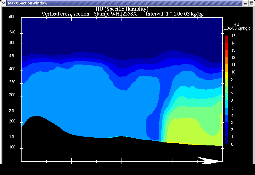
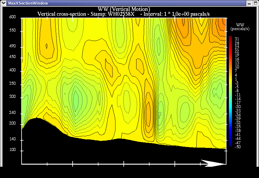
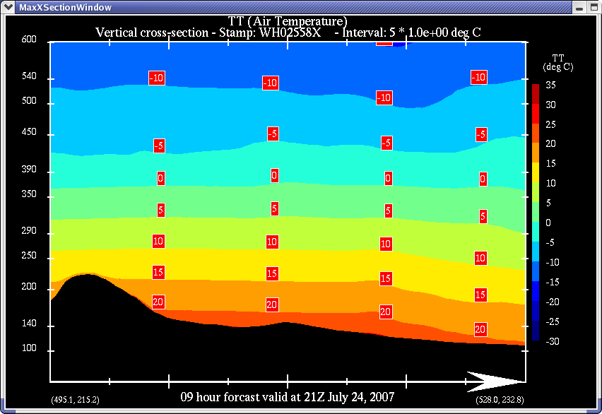
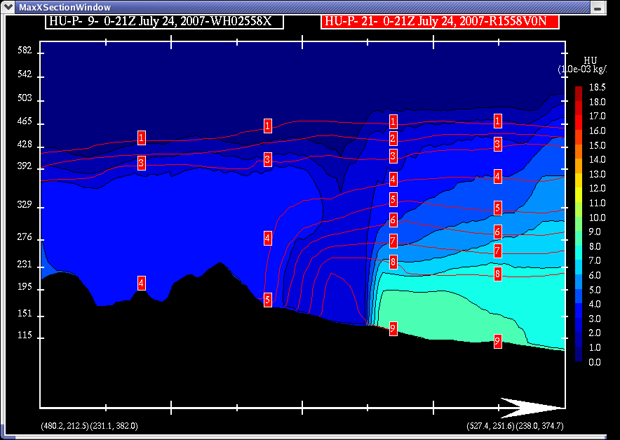
Cross sections of a a few fields were generated along the black arrow in the above mixing ratio image, the profiles discussed above mark the approximate end points of the cross sections shown below. The image at left is a cross section of mixing ratio, at center is vertical velocity, and on the right is temperature.
| Mixing Ratio |
Vertical Velocity |
Temperature |
 |
 |

|
The mixing ratio cross section shows a very strong moisture gradient associated with the dryline boundary over the lowest 1 km or so AGL (heights on the left in the figure are in 10s of m ASL). To the left of this gradient the ABL is well mixed with a mixing ratio of ~4-5 g/kg (since BUFR profiles are interpolated to points there may be some differences between the cross section values and those in the BUFR profiles). At the location of this cross section there appears to be an additional intrusion of dry air to the surface immediately to the left of the strongest moisture gradient. Examination of the mixing ratio and other plan-view images above suggests that this may occur at preferred locations where subsidence in the dry air near the dryline is strongest (i.e., the descending branch of horizontal rolls). The moist air to the right of the dryline in the figure is well-mixed at a mixing ratio in the 8-9 g/kg range over slightly less than the lowest 1km or so AGL and deepens to the right in the figure towards the lower terrain. Above the capped ABL, moisture decreases with height until it has the same mixing ratio as the ABL on the dry side of the dryline. This mixing zone is evident on the Sundre profile above the well-mixed ABL. Above ~4km ASL the troposphere is very dry as is clearly shown in both BUFR profiles.
The vertical velocity cross section exhibits a number of features of interest. Most notable is the presence of a deep vertical plume of ascent just slightly to the dry side of the strongest moisture gradient. This updraft extends at least over the lowest 5km AGL in the model but is not associated with any precipitation in the model at this location. Adjacent to the deep updraft on the dry side is a strong downdraft that appears to be associated with the dry air intrusion to near the surface as shown in the mixing ratio cross section. The moist ABL appears to be dominated by ascent with two weak vertical jets evident in the moist air and extending into the mixing zone above the cap. Closer to the higher terrain in the dry air there are two pronounced areas of ascent, one to the extreme left in the figure that is likely due to orographic ascent in westerly winds, and a second that seems to originate at the base of the largest slope in the figure. The origin of the second area of ascent is unclear though conceptually it would make sense for the ascent here to be due to heating of elevated terrain. While there is little difference in the coarse temperature cross section, examination of the BUFR profiles shows a difference in potential temperature below 2km ASL (~800 mb). If differential heating were the cause then the vertical velocity cross section may be indicating the presence of a mountain-plain (MP) circulation. This would be supported by the area of descent that penetrates the dry ABL to the right of the ascent area just discussed, i.e., this may be part of the downward branch of the MP circulation. Above the dry ABL (i.e., above ~4km ASL) there are hints of a wave pattern with weak alternating ascent / descent areas. Given flow over the mountains is nearly perpendicular to the terrain barrier, winds are increasing with height, and there is increased stability above the height of the mountains, these could be gravity waves generated by flow over the mountain barrier. Directly downstream of the updraft associated with convergence at the dryline a strong area of descent penetrates into the mixing zone between the moist and dry-overrunning layers, it could be that this is due to constructive interference between the descending branch of a lee wave and downstream descent in response to the dryline updraft creating a wave-breaking effect. It is not clear at this stage if this is a plausible explanation for this area of descent.
Considering the information from the BUFR profiles and cross sections discussed above, a composite schematic has been produced showing a cross-section normal to the dryline in an effort to highlight features of interest.

On the left and right of the figure are the GEM LAM BUFR profiles on the dry and moist sides of the dryline, respectively. In the center is a composite schematic based on information already presented. The profiles have been cropped and resized in an effort to match the vertical scale of the cross section images (heights in the center graphic are in m ASL). Solid black lines are mixing ratio lines, dashed brown and green lines are the top of the dry and moist ABL, respectively. The mixing layer between the dry and moist air is enclosed with an orange dashed line. Blue (red) shaded areas represent general ascent (descent) and arrows of the same colours represent axes of model vertical velocity (though not necessarily the direction of velocity vectors in those areas). Areas of strong ascent (descent) are indicated with blue (red) heavy ovals. Black circular arrows represent the locations of possible small-scale circulations. Most of the features highlighted in this graphic have been described in the text. The moist ABL is enclosed with the highest mixing ratio lines and capped by an elevated mixed layer of warmer air (higher potential temperature). Two small-scale circulations are indicate in close proximity to the dryline boundary, the first is at the interface between ascent/descent at the boundary and the second is near the mixing layer above the capped ABL on the moist side of the dryline. More research is needed to determine whether these circulations are produced repeatedly by the GEM LAM on different days and in different locations.
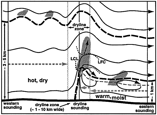
The above composite is similar to conceptual models that have appeared in the literature for drylines in the US. These models served as a starting point for the graphic created here and the similarities are encouraging as the dryline over the foothills (at least as simulated by the GEM LAM In this case) would seem to exhibit similar features as drylines observed elsewhere. Below is a graphic from Ziegler and Rasmussen (1998, Wea. Forecasting, 13, 1106-1131 - hereafter ZR98) showing their conceptual model for the dryline and associated flow based (at least partially) on observational studies.

The GEM LAM produces a convergence boundary associated with a strong moisture gradient characterized by a deep, well-mixed ABL on the dry side and a shallower, capped, moist ABL on the moist side of the boundary. The depths of the boundary layers on both sides of the dryline in the GEM LAM simulation are comparable to those described by ZR98. The LAM simulation indicates the presence of an elevated mixed layer overrunning the capped, moist air with the same characteristics as the ABL in the dry air. There is evidence of an elevated circulation downstream of the dryline updraft as has been found by ZR98 and others. Both the GEM LAM simulation and the conceptual model from ZR98 show the presence of gravity waves above the depth of the dry ABL. There has been some uncertaintly as to whether the moisture/convergence boundary frequently in Alberta behaves as a dryline or some other feature. Examination of this modle simulation suggests that the dryline in Alberta may indeed hold many similarities to drylines observed elsewhere.
A Quick Comparison to GEM 15 km
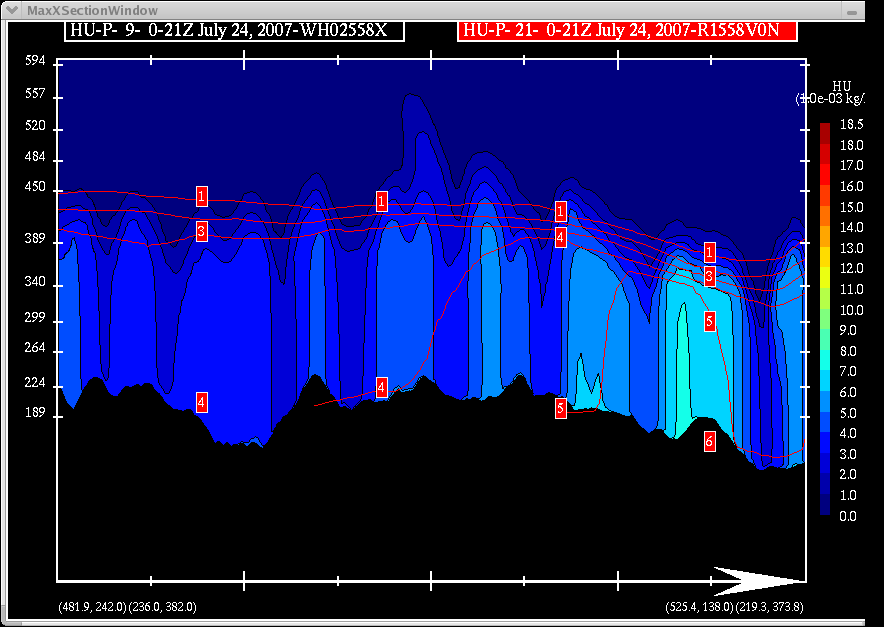
A few images from the 15 km configuration of the GEM run at 00Z 24 July 2007 were also generated for comparison with the GEM LAM. Here a longer cross section was taken generally through the same area as above but extending southwest all the way to the Alberta border. All images are for 21Z 24 July 2007, i.e., the 21 hr prog from the GEM 15 km and the 9 hr prog from the GEM 2.5km. Both images below compare LAM and GEM REG mixing ratio, the colour output is the LAM output while the open contours are from the GEM 15 km.
| Mixing Ratio GEM 15 and GEM 2.5 |
Cross Section |
 |
 |
In general both configurations of the model compare reasonably well but with some differences. The moisture gradient in the LAM is much tighter than in the REG run. While the general shape of the dryline is similar in both, a large section of the dryline appears closer to the mountains in the REG model. The LAM shows much more along-line variability including the presence of small-scale vortices. These circulations are not present in the REG run where the dryline appears to have a somewhat stepped appearance (a product of the larger grid or an attempt to resolve smaller-scale features of the dryline?). The cross section image shows that the regional model can only hint at the tight gradient in the LAM simulation so that the dryline boundary appears to be only inferred. The REG model does not reproduce the intrusion of drier air to the surface that appears in the LAM simulation directly to the left (west) of the dryline boundary. The magnitudes and depths of the mixing ratio in both simulations are comparable for both the dry air and the moist air on either side of the dryline.
A second pair of images were generated parallel to the terrain and dryline to see the vertical structure of the mixing ratio field across the direction of mean flow. Here there is a significant difference in the simulations. In the GEM 15km model the mixing ratio is nearly uniform with latitude and with height as the air passes over the mountains and onto the foothills. The increased resolution in the LAM simulation resolves variability in mixing ratio that is presumably associated with terrain effects as the air descends towards the plains. The banded structure of the mixing ratio field at the surface in the LAM is maintained through the depth of the ABL on the dry side of the dryline so that bands of moist and dry air develop parallel to the flow. This banded structure does not appear to be resolved by the GEM REG model.
| Mixing Ratio GEM 15 and GEM 2.5 |
Cross Section |
 |
 |
Dryline-Associated Misocyclones?
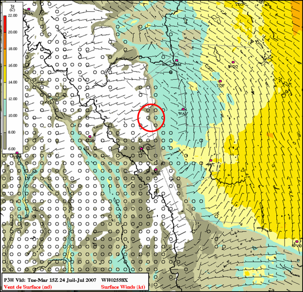
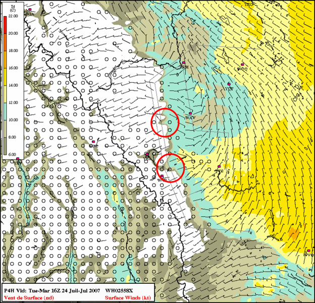
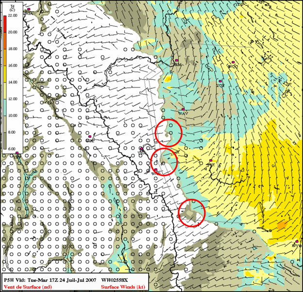
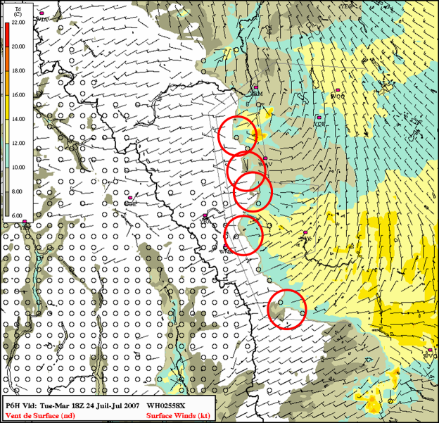
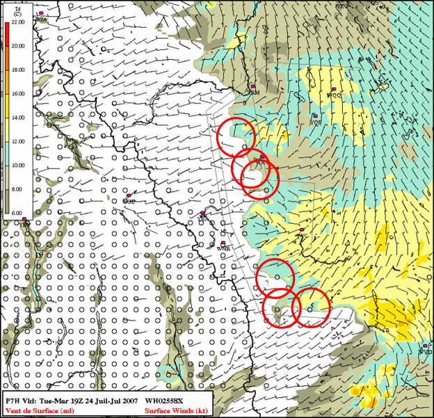
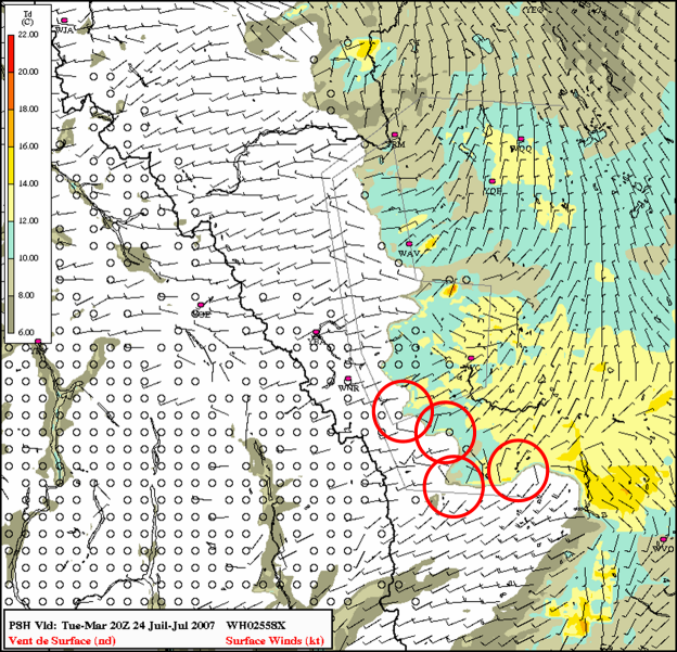
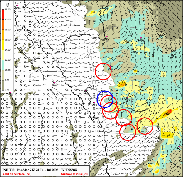
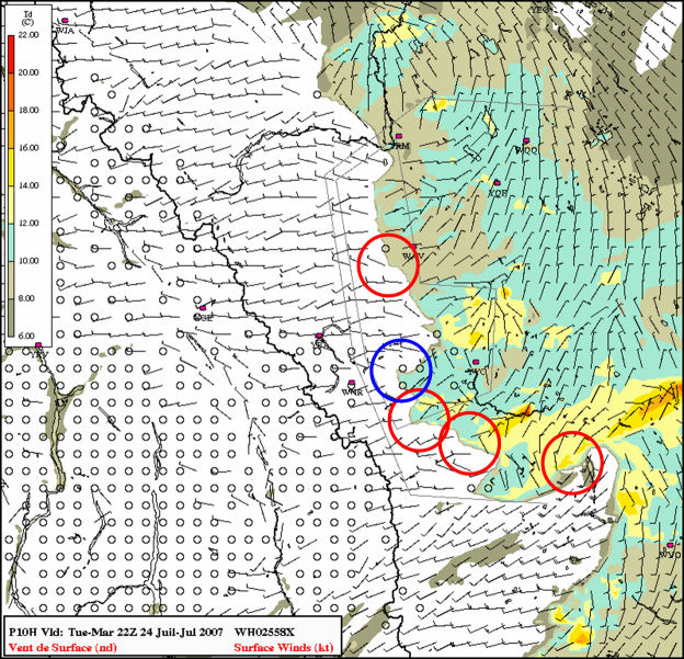
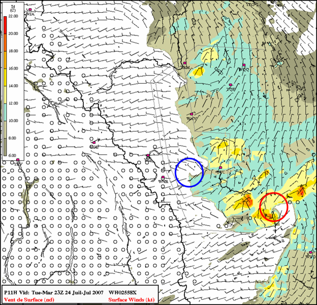
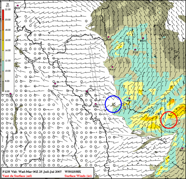
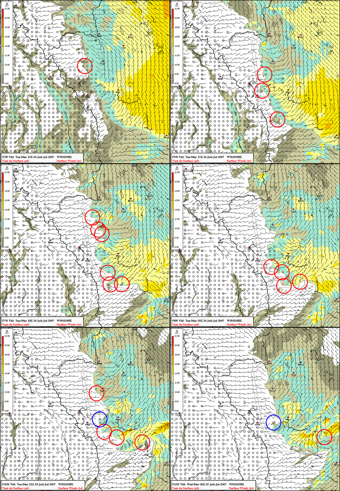
Misocyclones are small scale circulations (on the order of 1 km) that have been observed along convergence boundaries and associated with dryline motion, convective initiation, and non-supercell tornadogenesis. Recent research has investigated and documented the presence of these circulations along the dryline in association with along-line variability in wind (i.e., convergence) and moisture fields. A detailed discussion on misocyclones is beyond the scope of this study but hints of their presence in the GEM LAM simulation are intriguing. Hourly GEM LAM fields show the presence of multiple small-scale vortices associated with the dryline through its evolution on the 24th of July. The most persistent of these vortices is produced at the inflection of the dryline bulge that occurs near the southern boundary of the UNSTABLE domain in the model simulation (this vortex is of larger scale and may be more of a "mesolow" than a misocyclone). This vortex then moves to the east for several hours. Hourly dewpoint and wind images from the LAM simulation are shown below. The dewpoint images were chosen as they show deformation of the moisture field due to the circulations. Relative vorticity would be an interesting field to examine though it was not readily available when these images were made. Red (blue) circles indicate cyclonic (anticyclonic) circulations. Below the static images an animation is also included. It is unclear what significance these features may have for CI and storm evolution (or if they are even real!) but their presence in the model simulation warrants further investigation.
| 15Z |
16Z |
17Z |
18Z |
19Z |
 |
 |

|  |
 |
| 20Z |
21Z |
22Z |
23Z |
24Z |
 |
 |

|  |
 |

Summary
A preliminary and informal investigation into a simulation of the the dryline by the GEM LAM 2.5 km model on 24 July 2007 has been presented. The rationale for documenting this case was as an exercise to see how the high-resolution model represents the dryline. Of primary interest was whether the model-simulated dryline over the Alberta foothills exhibits features similar to those that have been both observed and simulated on the US Plains. This study did not focus on a verification of the model against surface, and other, observations though this should be undertaken in the future. Only one case and a few fields have been examined thus far but further investigation would be desireable to get a sense of how well and consistently the model can simulate the dryline.
The following summary points are based on information presented from this one dryline simulation:
- On 24 July 2007 the GEM LAM 2.5 km 12Z model run produced a dryline-like strong moisure gradient and convergence boundary over the Alberta foothills similar in location to a dryline that was observed to result in the initiation of a severe thunderstorm.
- Both the observed and model boundaries occured under synoptic conditions that have been previously identified as being conducive to the development of the dryline in Alberta.
- Both observed and simulated drylines took on a bulging character with the axis of the bulge extending along the axis of stronger winds at 700 mb. Stronger SFC winds in the dry air behind the bulge are evident in SFC observations and the model simulation suggested mixing to the SFC of upper-level momentum leads to stronger dry air advection and the bulging of the dryline.
- Moisture gradients across the simulated dryline are in excess of 10 degrees C dewpoint and ~5 g/kg mixing ratio. Observed dewpoint gradients along the dryline could be as high as 14 degrees C though with sparse SFC observations it is difficult to to get a true measure of the gradient.
- The simulated dryline exhibits a high degree of along-line variability in moisture, wind, and low-level vertical motion fields. This variability is not evident in coarse SFC observations of real drylines in Alberta or in 15 km GEM simulations though it has been observed with both real and model-simulated drylines in the US.
- The model vertical motion field in the dry air to the west of the dryline is dominated by subsidence, at least below 700 mb. The banded vertical velocity structure in the dry air suggests the presence of horizontal rolls oriented parallel to the flow. Model SFC winds show a response to areas of ascent/descent aloft and support the notion of horizontal rolls in the dry air. It is unclear whether the updraft branches of these rolls (if they are in fact real) could play a role in CI along the dryline.
- The axis of ascent along the dryline in the GEM LAM appears to be vertically oriented though it is difficult at this point to determine the actual 3D wind vectors. This dryline updraft extends through 700 mb or at least 5 km AGL.
- ABL depths on the dry and moist side of the model dryline are ~2300 m AGL and ~700 m AGL, respectively with nearly constant mixing ratio through that depth. The strong moisture gradient along the dryline extends to ~ 1 km AGL in the model simulation. BUFR profiles show a well-mixed, dry elevated layer over the moist ABL that originates to the west of the dryline. This implies the ABL on the dry side of the boundary overruns the capped ABL on the moist side as has been shown for the dryline in the US. Between the two layers to the east of the dryline a mixing zone is evident in the vertical.
- Immediately on the dry side of the dryline there appears to be areas where an intrusion of drier air is able to reach the surface, the mechanism responsible for this is unclear.
- Gravity waves appear to be present above the height of the deep, dry ABL. These waves may interact with the dryline updraft to produce enhanced ascent or descent in vicinity of the dryline, this notion merits further investigation.
- Overall the simulated dryline exhibits characteristics similar to those in conceptual models for the dryline in the US. Further investigation is required into the main forcing mechanisms responsible for genesis and evolution of the dryline over Alberta.
- Comparison with the GEM 15 km model shows the LAM produces increased along-line variability in thermodynamic and kinematic fields over the coarser model. The GEM 15 places portions of the dryline closer to the mountains than the LAM, cannot reproduce a tight moisture gradient, and does not resolve the banded moisture and vertical velocity features simulated by the LAM in the dry air.
- The LAM simulation produces small-scale vortices along the dryline that deform the moisture and low-level vertical motion fields. These "misocyclones" have been observed and simulated with dryline in the US and are thought to be important for CI and non-supercell tornadogenesis along convergence boundaries.
It is encouraging to see the GEM LAM reproduce a dryline over the Alberta foothills with characteristics similar to drylines observed elsewhere. This study introduces some features likely never before discussed in association with the dryline and CI over the Alberta foothills. Namely, horizontal rolls in the dry air parallel to the mid-level winds, dry air intrusions to the surface near and to the west of the dryline, and the presence of misocyclones along the dryline. It remains to be seen if these features are observed in nature and if so, what their role may be in dryline evolution and CI over the foothills. It is hoped that the UNSTABLE field experiment planned for summer 2008 will allow further investigation of these features in both the real and model worlds.
Acknowledgements
Thanks to Garry Toth of the HAL for taking the time to sit with me and generate the LAM images from MAX, especially the cross-sections. He has been leading a much more complete evaluation of the LAM this past convective season than I have and continues to assess the utility of the LAM for forecasting convection on the prairies. Thanks also to Neil McLennan from Pacific and Yukon Region who has been of great aid to our efforts in evaluating the GEM LAM in Alberta over the last two convective seasons. His generation of the UNSTABLE domain on his experimental page (found
here)
is of great benefit for the planning of UNSTABLE and will become a mainstay of GEM LAM evaluation during the project in the summer of 2008.
Suggested Reading
Here's a few 'recent' dryline papers...
Buban, M. S., C. L. Ziegler, E. N. Rasmussen, and Y. P. Richardson, 2007: The dryline on 22 May 2002 during IHOP: Ground-radar and in situ data analyses of the dryline and boundary layer evolution. Mon. Wea. Rev., 135, 2473-2505.
Demoz, B., and Coauthors, 2006: The dryline on 22 May 2002 during IHOP 2002: Convective-scale measurements at the profiling site. Mon. Wea. Rev., 134, 294-310.
Hane, C. E., H. B. Bluestein, T. M. Crawford, M. E. Baldwin, and R. M. Rabin, 1997: Severe thunderstorm development in relation to along-dryline variability: A case study. Mon. Wea. Rev., 125, 231-251.
Hane, C. E., R. M. Rabin, T. M. Crawford, H. B. Bluestein, and M. E. Baldwin, 2002: A case study of severe storm development along a dryline within a synoptically active environment. Part II: Multiple boundaries and convective initiation. Mon. Wea. Rev., 130, 900-920.
Markowski, P. M., C. Hannon, and E. Rasmussen, 2006: Observations of convection initiation "failure" from the 12 June 2002 IHOP deployment. Mon. Wea. Rev., 134, 375-405.
Murphey, H. V. , R. M. Wakimoto, C. Flamant, and D. E. Kingsmill, 2006: Dryline on 19 June 2002 during IHOP. Part I: Airborne Doppler and LEANDRE II analysis of the thin line structure and convection initiation. Mon. Wea. Rev., 134, 406-430.
Pietrycha, A. E., and E. N. Rasmussen, 2004: Finescale surface observations of the dryline: A mobile mesonet perspective. Wea. Forecasting, 19, 1075-1088.
Weiss, C. C., H. B. Bluestein, and A. L. Pazmany, 2006: Finescale radar observations of the 22 May 2002 dryline during the International H2O Project (IHOP). Mon. Wea. Rev., 134, 172-191.
Xue. M, and W. J. Martin, 2006: A high-resolution modeling study of the 24 May 2002 dryline case during IHOP. Part II: Horizontal convective rolls and convective initiation. Mon. Wea. Rev., 134, 273-293.
Ziegler, C. L., T. J. Lee, and R. A. Pielke Sr., 1997: Convective initiation at the dryline: A modeling study. Mon. Wea. Rev., 125, 1001-1026.
Ziegler, C. L., and E. N. Rasmussen, 1998: The initiation of moist convection at the dryline: Forecasting issues from a case study perspective. Wea. Forecasting, 13, 1106-1131.
Contact: Neil Taylor
